


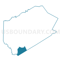
Voting District 090002, Delaware County, New York
About
Outline

Summary
| Unique Area Identifier | 626179 |
| Name | Voting District 090002 |
| County | Delaware County |
| State | New York |
| Area (square miles) | 42.07 |
| Land Area (square miles) | 41.78 |
| Water Area (square miles) | 0.29 |
| % of Land Area | 99.31 |
| % of Water Area | 0.69 |
| Latitude of the Internal Point | 41.90620820 |
| Longtitude of the Internal Point | -75.09205900 |
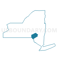
Maps

Graphs
Select a template below for downloading or customizing gragh for Voting District 090002, Delaware County, New York


Neighbors
Neighoring Voting District (by Name) Neighboring Voting District on the Map
- Voting District 030002, Delaware County, NY
- Voting District 070001, Sullivan County, NY
- Voting District 070002, Sullivan County, NY
- Voting District 090001 090005, Delaware County, NY
- Voting District 090003, Delaware County, NY
- MANCHESTER TWP Voting District, Wayne County, PA
Top 10 Neighboring County Subdivision (by Population) Neighboring County Subdivision on the Map
- Hancock town, Delaware County, NY (3,224)
- Colchester town, Delaware County, NY (2,077)
- Fremont town, Sullivan County, NY (1,381)
- Manchester township, Wayne County, PA (836)
Top 10 Neighboring Unified School District (by Population) Neighboring Unified School District on the Map
- Wayne Highlands School District, PA (20,842)
- Sullivan West Central School District, NY (10,576)
- Hancock Central School District, NY (2,724)
- Downsville Central School District, NY (2,183)
- Roscoe Central School District, NY (2,086)
Top 10 Neighboring State Legislative District Lower Chamber (by Population) Neighboring State Legislative District Lower Chamber on the Map
- Assembly District 98, NY (138,734)
- Assembly District 107, NY (125,994)
- State House District 111, PA (59,947)
Top 10 Neighboring State Legislative District Upper Chamber (by Population) Neighboring State Legislative District Upper Chamber on the Map
Top 10 Neighboring 111th Congressional District (by Population) Neighboring 111th Congressional District on the Map
- Congressional District 20, NY (683,198)
- Congressional District 22, NY (679,297)
- Congressional District 10, PA (669,257)
Top 10 Neighboring Census Tract (by Population) Neighboring Census Tract on the Map
- Census Tract 9714, Delaware County, NY (3,224)
- Census Tract 9713, Delaware County, NY (2,077)
- Census Tract 9503, Sullivan County, NY (1,381)
- Census Tract 9601, Wayne County, PA (1,356)
Top 10 Neighboring 5-Digit ZIP Code Tabulation Area (by Population) Neighboring 5-Digit ZIP Code Tabulation Area on the Map
- 13783, NY (2,670)
- 12776, NY (2,180)
- 18417, PA (1,121)
- 13756, NY (613)
- 12760, NY (482)
- 13774, NY (201)